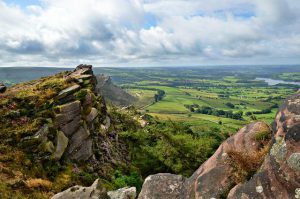
As indicated by the regional name, the terrain is mostly moorland with forests and lakes stretching out across rolling hills and crags. Some of the higher moorland has been largely abandoned for farming. Several Wallabies roamed free for many years in The Roaches, a series of gritstone outcrops within the Peak Park which rises to 505m (1,657 feet). The highest point in both the district and Staffordshire is Cheeks Hill, rising up to 520m (1,710 feet) on Axe Edge Moor.
Most of the upland terrain within the district forms the southern end and foothills of the Pennines. A large proportion of the ‘white peak’ area of the Peak District is contained within the Staffordshire Moorlands. This includes such places as one half of Dovedale, the Manifold Valley including Thor’s Cave, Wetton Mill, Longnor and Butterton. The Staffordshire Moorlands also contains the wooded Churnet Valley, a steep sided valley running between Cheddleton and Rocester also known as “The Rhineland of Staffordshire” or Staffordshire’s “Little Switzerland”.
The Staffordshire Moorlands is also home to the highest village in Britain, Flash. The village stands at 463m (1,518 feet) above sea level. This record was confirmed in 2007 by the Ordnance Survey after Wanlockhead in Scotland also claimed the record. The BBC’s The One Show investigated the case in a bid to settle the argument and Flash turned out to be the higher of the two.
The council maintains a number of local nature reserves including Biddulph Valley Way, Brough Park Fields, Cecilly Brook, Hales Hall Pool, Hoften’s Cross Meadows, Ladderedge Country Park and Marshes Hill Common.